Tag: Roman

A Roman Glass Mosaic in Purton, Wiltshire

An article in the Wiltshire Archaeological and Natural History Magazine of 1920 summarised Roman finds near Purton, Wiltshire.  It mentions the discovery of a probable Roman villa in Victorian times but then goes on to say “This find is not to be connected with fragments of mosaic of glass said to have been recently found at this place, which are obviously of foreign make and comparatively modern date.”  So, the authors are saying that sometime after the Roman villa was abandoned somebody came along and built a house with a glass mosaic in exactly the same place; this seems highly unlikely.

Glass mosaics are known from other parts of the empire and there is a famous example in Vienne in France.  There are also some examples of glass being used in mosaics much closer to home.  The Corinium museum in Cirencester (about 12 miles from Purton) has several mosaics from Roman Cirencester.  The hare mosaic which is displayed prominently near the entrance to the museum has glass tesserae along the back of the hare, and the seasons mosaic has glass tesserae in two different panels.  The head of Flora, representing spring, has tesserae of red glass in her hair.  When first discovered the tesserae were not so vibrant as the red glass had become discoloured with age but when polished the red colour was restored and the red flowers became apparent.  Red glass tesserae were also used in the panel showing the hunter Actaeon being attacked by his own dogs.  Actaeon had dared to gaze upon the goddess Diana as she bathed. When Diana saw Actaeon she turned him into a stag but his dogs no longer recognised him and attacked him, and this scene is depicted in the mosaic.  The blood coming from Actaeon’s leg is depicted with tesserae made of red glass.  Clearly there is a local tradition of using glass tesserae in mosaics in the Cirencester area so it is highly likely that the glass mosaic discovered at Purton in the early 20th century was Roman. Cirencester was home to a school of mosaicists who installed mosaics across the region so it is possible that the use of glass in mosaics was more widespread than we currently realise.

So where did these fragments of coloured glass come from?  It is generally accepted that there was no primary glass manufacturing in Roman Britain.  Raw glass appears to have been imported then re-melted to produce glass items.  Fahy noted the correlation between ceramic production sites and glass production sites and both industries require high temperature kilns, sources of fuel and a skilled workforce.  If the glass fragments were produced in Britain rather than being imported then Purton would be a possible manufacturing site.  Apart from the tile manufacturing site at Minety, it is the closest kiln site to Cirencester and has a similar operational date to the mosaics being produced with glass tesserae.  Anderson dated the pottery from the kiln site to the mid 2nd century and Witts says that the seasons mosaic could be dated to the late 2nd century or early third century. Cosh dates it to the 2nd century.  It is certainly possible that the dates overlapped. My conclusion is that the “fragments of mosaic of glass” were part of a 2nd century mosaic installed in a Roman villa at Purton.  Furthermore, the glass fragments may have been produced at the nearby kilns, only 100m from the villa site.

The siting of the kilns found at Dogridge in 1975 is unusual.  Usually, kilns are located on the clay that is used to produce pottery but here the bedrock is limestone.  There is a deposit of Ampthill/Kimmeridge clay about 200m to the south but there is no evidence of any clay pits in this area.  There are larger deposits a bit further afield and deposits of Oxford clay on lower ground to the north and west, but if they used this clay why didn’t they put the kilns where the clay was?  The location away from clay deposits suggests the kilns weren’t used for high volume production.   If they had wanted high volume production they would have put the kilns closer to the source.
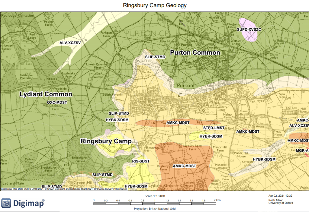
The Purton kilns were discovered during housebuilding.  Anderson was able to inspect the kilns but was not able to conduct a proper archaeological investigation before the site was developed.  He thought there could be as many as six kilns on the site and noted an unusual kiln design for kiln 1.  The flue was almost as wide as the body of the oven.  Anderson also noted the presence of unfired clay and potsherds.  It is possible that the location of the kilns on higher ground and the wide flue were both designed to increase the airflow through the kiln and produce higher temperatures.  The Romans in Purton project dug a test pit about 20 m south-east of the location of the kilns in the HER found no evidence of pottery manufacturing but did find a small piece of slag, “probably related to metalworking” so it is certainly possible that the kilns were used for metal or glass production.

The Romans in Purton project dug test pits in the gardens of volunteers in the Dogridge and Pavenhill areas.  Six tesserae were found in the gardens of houses on the opposite side of Pavenhill from the Royal George pub.  The tesserae appear not to be cut from fired pottery.  They appear to be comparitively small and shaped before firing, with slightly concave faces as would be produce if wet clay was shaped into a cube by fingers.  These smaller tesserae were most likely produced to be part of a mosaic with a pictorial design, not simply a geometric pattern.  They could also have been produced in the Purton kilns.

References

Anderson, A.S. (1979) The Roman Pottery Industry in North Wiltshire. Thamesdown Borough Council

Buckman and Newmarch, C. H. (1850) Illustrations of the Remains of Roman Art in Cirencester.  George Bell, London

Cosh, S. R. (2026) Mosaics in Britannia.  Archaeopress, Bicester

Hood, A. (2026) The Romans in Purton Project, Purton, Wiltshire. Foundations Archaeology https://www.purtonmuseumandhistoricalsociety.com/latest-news

Rainey, A (1973) Mosaics in Roman Britain, A Gazetteer. David and Charles, Newton Abbot

Witts, P. (2010) Mosaics in Roman Britain, Stories in Stone. The History Press, Stroud
The Search for Lutudarum

Lutudarum is a Roman place name listed in the Ravenna Cosmography.  It is in a group of places in Cheshire and Derbyshire and is listed next to Derventio, believed to be the Roman fort of Little Chester, just north of Derby City Centre. 

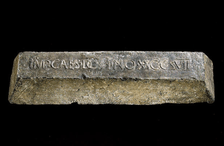
The Romans mined lead in Derbyshire and cast smelted lead into blocks known as pigs.  These pigs of lead are known to be Roman because of the inscriptions in Latin.  The inscriptions often include (in abbreviated form) the name of the emperor at the time of casting or the name of individuals trading the lead, and sometimes the abbreviation LVT.  It is a reasonable assumption the LVT refers to Lutudarum and that this was a settlement or fort connected with lead mining.  The location of Lutudarum has been the subject of much speculation and Chesterfield, Crich, Matlock, Cromford, Wirksworth and Carsington have all been proposed as possible locations.  Harry Lane in his book ‘The Romans in Derbyshire’ reviewed the evidence for the various locations and also considered several known Romano British settlements.  There is so much speculation because there is no evidence. Wirksworth was favoured by many as a possible location because of its later role as an administrative centre for lead mining but there is absolutely no evidence of a Roman settlement in Wirksworth.

Fig. 1 Roman Pig of Lead from Yorkshire

My objective in this blog is to map the distribution of the pigs of lead that can be attributed to a Derbyshire origin to see what we can deduce about the source and distribution of the lead. Pigs of lead from Derbyshire have been found as far north as the Humber estuary and as far south as Sussex.

Fig.2 The distribution of Derbyshire pigs of lead in Britain

There is an obvious concentration of pigs of lead in central Derbyshire

Fig.3 Roman Pigs of Lead in Derbyshire

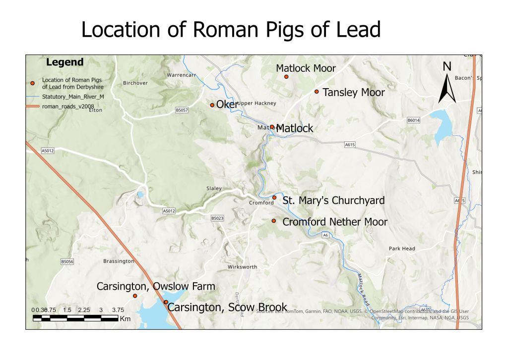
Fig.4 Roman pigs of lead in Matlock/Cromford/Wirksworth area

The largest concentration of pigs of lead is in the Matlock/Cromford/Wirksworth area and there is a group of six pigs of lead that are not close to a known Roman road.  Most of the other known pigs of lead are within a few miles of a known Roman road.

From the distribution of the pigs of lead it looks as if there several sources of lead and several smelting sites within a fairly small area.  If there was one smelting site you would expect the pigs of lead to be concentrated in a particular area or along a particular route.  So, if there were several extraction sites and several smelting sites. Lutudarum was not necessarily directly involved in the process.  It may have just been an administrative site for this area.

Since all six of this group are not near known Roman roads but are close to the River Derwent this is the most likely route for transport out of the area. In his book, Lane argues that the Derwent was probably navigable by shallow-draughted boats in the Roman period.  It looks as if some pigs of lead were transported all the way down the Derwent then down the Trent to Petuaria (Brough on Humber).  Three of the pigs of lead from this area (Broomfleet, South Cave and Ellerker) were found in parishes along the north bank of the Humber Estuary between the outflow of the Trent and Petuaria suggesting that this was the route.  Some have suggested that these pigs of lead were destined for export but it is more likely that they were heading for York which was being rebuilt in stone at the end of the first century and the start of the second century. The lead had been floated downstream via the Derwent and Trent but was too heavy to be transported upstream via the Ouse so was transferred to the Roman road from Petuaria to York. Other pigs of lead appear to have been distributed via the Roman road network and may have joined the road network at Derventio (Little Chester, Derby). 

There have been several archaeological digs at Little Chester (Derventio) by York Archaeology.  The most recent finished in August 2025 and raised questions about the status of the Roman occupation of the site. Although the excavated remains clearly show the classic playing card shape of a Roman fort there is very little archaeological evidence for a military presence and the archaeologists prefer to use the term “defended settlement” when talking about the site.  The defences are quite close to the River Derwent so if Derventio had a role in controlling river traffic you would expect a harbour or wharves or maybe just a beach, but no evidence of this has yet been found.  The only hint that this “harbour area” did have an important role is a defensive ditch on the north side.  It is possible that Derventio was a distribution centre for Derbyshire lead, with lead being off-loaded from small vessels onto larger vessels for its journey downstream along the Trent, or the Roman roads running north and south along Ryknield Street and west along Long Lane.

What does this tell us about the location of Lutudarum?

If the majority of the lead mined in the late 1st or early 2nd century was coming from the Matlock/Cromford/Wirksworth area and was being transported out of the area down the Derwent, it would make no sense to have the administrative centre in Chesterfield or Crich.  My guess (and it is only a guess) is that Lutudarum would be sited at a strategic location where the Romans could monitor lead production (eg making sure that the locals aren’t smelting their own lead for the black market) and also monitor the transport of lead out of the area.  The best place to perform this latter task would be at Cromford; all the lead would come downstream to here and lead from Cromford Nether Moor would join the Derwent here.

There are two interesting sites in Cromford.  Firstly there is the flat area of ground just below the Cromford Mills Car Park.  Part of this area was where the Arkwright family built their family chapel, now St Mary’s church, and the other part is Smelting Mill Green, known to have a lead smelter here in 1575.  This area would be large enough to accommodate a small Roman fort and is ideally placed to monitor traffic on the Derwent.

Fig.5 St. Mary’s Church, Cromford

Fig.6 Information Board for Smelting Mill Green

The 1899 large scale Ordnance Survey map of the area shows a v-shaped cutting that gave access from the area to the River Derwent but without archaeological investigation it is impossible to date the feature.  However it does suggest that the river could have been used as a means of transport out of the area.

Fig.7 1899 Ordnance Survey map of Smelting Mill Green

The other site of interest in Cromford is St. Mark’s churchyard.  The church itself has been demolished but the graveyard is still in use.  This church preceded St. Mary’s as the parish church and some locals think that the pigs of lead found near St. Mary’s may actually have been found at St. Mark’s.  The interesting thing about the churchyard is that it is an almost perfect rectangle about 100m by 60m.  Almost Roman fort shaped!

Unfortunately there is very little archaeological evidence that supports any particular location.  There is a scattering of Roman finds from the Matlock/Cromford/Wirksworth area but nothing that would suggest a Roman settlement.

What about Carsington?

The Roman Roads map was published in 2008 and is now out of date.  On the map the road from Buxton to Little Chester was conjectural after Longcliffe, but Dave Ratledge’s LIDAR analysis has shown that the road runs very close to the Scow Brook site (now under Carsington Reservoir).  The problem I have with Carsington is the dating evidence.  The pigs of lead that mention LUT (Lutudarum) are late 1st or early 2nd century but the Scow Brook site seems to be later than this.  It has been badly damaged by ploughing and was difficult to date and there was very limited evidence for occupation before 150.  The pigs of lead from this area are 3rd or 4th century from their context.  There could be other sites in the vicinity that did exist in the early part of the occupation of Derbyshire but there is no reason to favour Carsington over other sites.

Other Romano-British sites in the area eg Rainster Rocks are also from a later phase of lead extraction.

In summary there is no archaeological evidence for a Roman settlement in the Matlock/Cromford/Wirksworth area of Derbyshire from the early part of the conquest.  My favoured location for the site of Lutudarum is Cromford but we need some archaeology.  I think I shall try Time Team!

References

Lane, H. (1986) The Romans in Derbyshire, Lead Mining and the Search for Lutudarum. Veritas Publications (Derbyshire), Bolsover

Ratledge, D. (2021) Derbyshire Archaeological Journal 141 7-31