In 865 the Anglo-Saxon kingdom of Mercia controlled central England. They were almost landlocked so the Viking raids of the 9th century had not had a great impact and the Mercians were more concerned with their traditional foes, the Welsh in the west, East Anglia in the east, Northumbrians in the north and the West Saxons in the south.

Anglo-Saxon kingdoms before the Vikings (Image © The Map Archive)
All that changed with the arrival of the Great Heathen Army in 865. The Vikings arrived in East Anglia then moved northwards through Mercian territory to capture York in 866. Their first serious attack on Mercia came the next year and they overwintered in Nottingham in 867/868. Combined forces of Mercia and Wessex were unable to dislodge the Vikings from Nottingham but the Vikings returned to York in 868. The next foray into Mercian territory took them to Torksey in Lincolnshire where they overwintered in 872/873 and the following year, 873/874 they overwintered at Repton. Now they had struck at the heart of Mercia. Repton was the burial place of Mercian kings and close to other important Mercian centres, Tamworth, Lichfield and Breedon on the Hill. This time they did more then settle down for the winter and forage for supplies. According to the Anglo-Saxon Chronicle they expelled the Mercian king, Burhred, and ‘conquered the entire kingdom’. They then installed Ceolwulf as king of Mercia before departing, Halfdan taking part of the army to Northumbria and the remainder going to East Anglia. From East Anglia the Great Heathen Army attacked Wessex and after a stand off at Exeter ‘the host departed into Mercia, and some of it they shared out, and some they gave to Ceolwulf’. Presumably, at this time Mercia was partitioned with the Vikings taking control and settling in Derbyshire, Nottinghamshire, Lincolnshire, Leicestershire and Northamptonshire, while English Mercia stayed under the control of Ceolwulf. This part of Mercia was still a sizable kingdom consisting of Cheshire, part of Lancashire, Staffordshire, Shropshire, Herefordshire, Worcestershire, Gloucestershire, Warwickshire, Oxfordshire, Buckinghamshire, Berkshire and London . The boundaries were a bit fluid; Berkshire and London were disputed with Wessex and the relationship between the five boroughs and the Viking kingdom of East Anglia is unclear.
The best evidence for the Viking settlement of Britain comes from place names. The map below shows all place names containing -by, -thorpe, -toft, -thwaite, -holm, -ness and -kirk. In Derbyshire and north Staffordshire there are very few Scandinavian settlement names west of Derby.
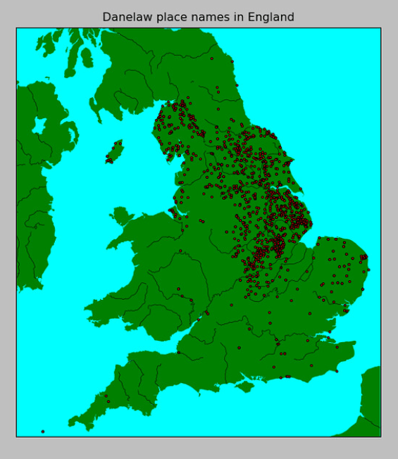
In the 1920s a hoard of Anglo-Saxon coins was discovered at Beeston Tor in the Manifold Valley in North Staffordshire (Wilson 1926). The coins were all pre 873 and were thought to have been hidden from Vikings who overwintered at Repton in 873-874. Beeston Tor is around 30 miles from Repton so suggests that Vikings from Repton were foraging over a fairly wide area. This in turn suggests that the Great Army numbered in their thousands rather than hundreds. This has been confirmed by recent discoveries near Repton by Cat Jarman. The original excavations at Repton by Martin Biddle and Birthe Kjølbye-Biddle in the 1970’s had found a D shaped enclosure that incorporated the Anglo-Saxon church into the defensive ditch so that the church acted as a gatehouse to get into the enclosure. The ditch had been cut at the time the Vikings were in Repton but the enclosed area was quite small, about 3.65 acres, so could not have held an army numbering in their thousands.
Recent discoveries have provided evidence for a Viking camp a few miles downstream from Repton near Foremark which is a Scandinavian place name meaning ‘fortified place’. Metal detectorists have been active in the area for some years and have found a range of objects similar to those found at Torksey, another Viking overwintering site. A few finds have been found further downstream at Stanton by Bridge. A significant Viking presence is also suggested by the Viking cremation barrow burials at Heath Wood where there were 59 burials. Nearby is the village of Ingelby which is the village of the English, named by Scandinavians. This suggests that the area had been settled by Vikings and the English in the area were in a minority.
There is also evidence for a Viking presence upstream from Repton. The Portable Antiquities scheme has records of 12 gaming pieces and a few other finds from Catton, close to the Trent on the eastern side about 12 miles upstream from Repton. Hadley and Richards (2018) noted that the range of finds was similar to that in known Viking camps although the quantity of finds was not extensive. They thought that it could have been the site of a temporary camp. On the west bank of the Trent opposite Catton (in an area much disturbed by gravel extraction) there are three holme names on the OS Explorer map, Borough Holme, Cat Holme and Cherry Holme. Two other holme names are mentioned in the ‘Where Rivers Meet’ study of the area, Tucklesholme Farm and Fatholme (Buteux and Chapman 2009). Holme usually means ‘island’ and in this context probably means an island of dry land created in the valley bottom (Ekwall 1960, 246)). Either the climate was getting drier when the Vikings claimed new land or the Vikings were draining the land to create dry land for farming.
We know that after overwintering at Repton the army split into two parts, one going to Northumbria and the other part to East Anglia, so perhaps they were always two armies, one camping at Foremark and the other at Catton.
Also upstream from Repton is the confluence with the River Dove. The obvious route for the Repton Vikings to get to Beeston Tor would be the river route via the Dove and Manifold Valleys. Is there any evidence for a Viking presence along this route? Surprisingly there is. There are very few Scandinavian place names west of Derby. One exception is Thorpe, just north of Ashbourne near the Dove Valley, but there is also a string of farm names ending in -holme between Ashbourne and Rocester. Buckholme, Holme Farm, Knaveholme, Swinholme, Clowneholme, Abbotsholme all appear in or alongside the river valley (Ordnance Survey Explorer Map 259). In this group all the -holme names are on the Derbyshire side of the river. Additionally, Denstone may mean settlement of the Danes (Ekwall 1960, 142). There is also a scatter of hybrid Viking place names across south Derbyshire. Branston, Scropton, Thurvaston, Burnaston, Rolleston, Stenson, Foston, Sturston, Kedleston, Swarkestone all consist of a Scandinavian personal name and -ton, the old English suffix meaning settlement (Gregory 2017). Two of these hybrid names, Scropton and Foston, are in the Dove valley and between them are two more holme names, Lemon’s Holme and Sweet Holme.
There are also a few place names north of Beeston Tor that may indicate a Scandinavian presence. According to Ekwall (1960, 246), Hulme is derived from Holme and Hulme End is therefore of Scandinavian origin. There are also a few names ending in -gate which is a Scandinavian word for road (Ekwall 1960, 193). Hayesgate, Grindonmoor gate, Gateham and Damgate are all close to the Manifold valley (Ordnance Survey Explorer Map OL24) but these may be related to a later deer park. If there was a Viking presence here, the attraction could be the deposits of lead and copper found near Ecton although there is no record of these being exploited before the conquest and there is no record of mining in the area in the Domesday book, so this is highly speculative.
River valleys are not the only routes used by the Vikings in south Derbyshire. A roman road runs from Little Chester on the northern side of Derby across to Rocester and beyond and for much of its route the line of the road has been preserved by a modern minor road. Thurvaston (hybrid place name) and Longford are close to this route and the Portable Antiquities scheme records a Viking silver ingot found at Longford.
There is also some evidence for a Viking presence west of Derby from sculpture. In a blog post on the East Midlands Viking site, Judith Jesch notes the presence of warriors on two cross shafts in south west Derbyshire, at Brailsford and Norbury (Jesch 2018).

The warrior on the Brailsford cross shaft is carved on a round shafted cross in the churchyard. Jesch quotes the Corpus of Anglo Saxon sculpture, which says that the figure is a memorial stone or marker of a member of the Anglo-Scandinavian warrior elite. I am not convinced. The warrior seems to be dressed in a similar fashion to the warrior on the Repton stone which predates the Viking occupation of Repton.
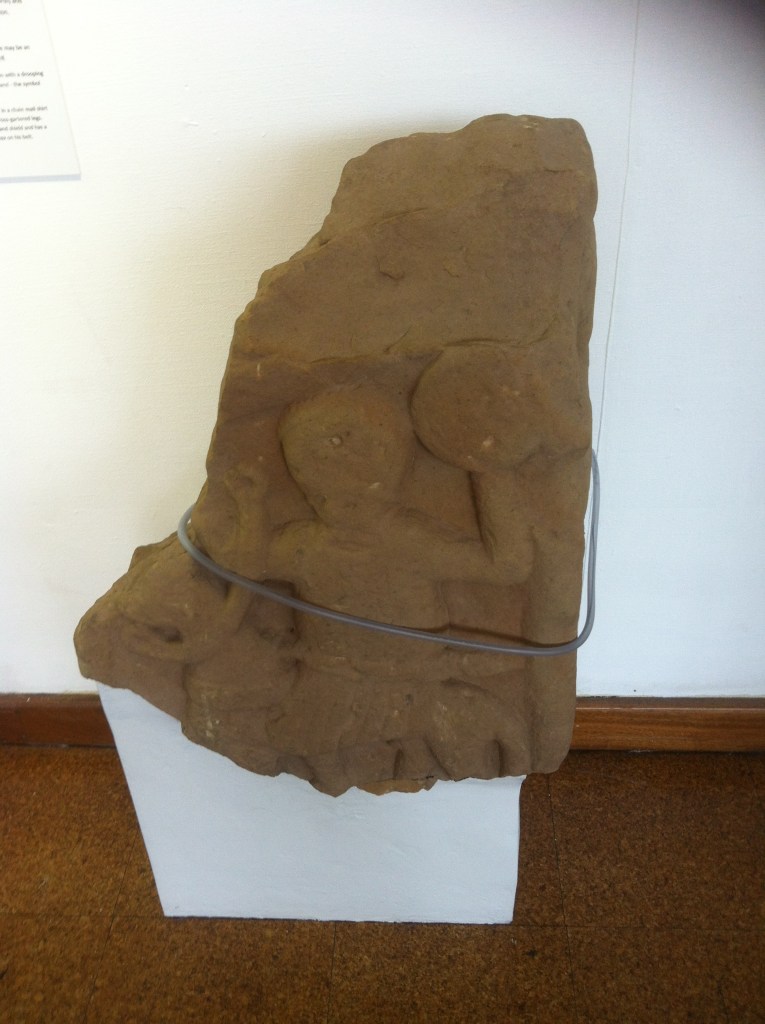
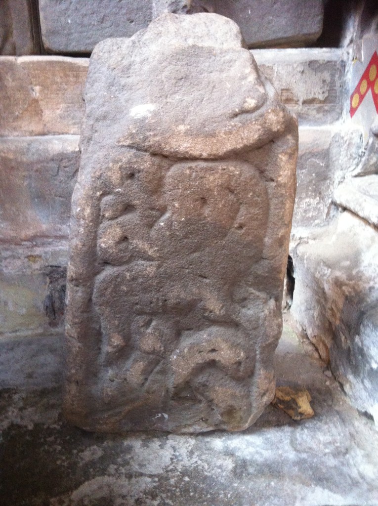
Both warriors have a seax carried horizontally across the waist and a small round shield. Both have plated armour and wear a skirted garment, the only difference being the presence or absence of a horse. The corpus dates the Brailsford cross shaft to around the 10th century but dating cross shafts is notoriously difficult. The other depiction of a warrior is on one of the crosses in Norbury church.

The corpus suggests that this is another memorial to a warrior but also raises the possibility that it represents the Norse god Heimdallr, blowing his horn to mark the start of Ragnarök. Realistically neither of these sculptures show Scandinavian design features. However there is one nearby sculpture that does show evidence of Scandinavian influence. There is a fragment of a cross shaft in the Boothby chapel in the parish church of St Oswalds in Ashbourne.

One face shows a Mamman style beast and the other faces show two or three stranded knotwork. The Corpus of Anglo Saxon Sculpture for Derbyshire and Staffordshire acknowledges the problems dating the stone and deciding if it is Mercian or Scandinavian but the fragment has design features that are similar to those on the hogback from St. Alkmund’s church in Derby (now in Derby Museum). Hogbacks are generally found in Scandinavian influenced areas and this one has the same double stranded knotwork with a pointed end going into the corners of the frame as found on the Ashbourne cross shaft. This confirms Viking influence across South Derbyshire
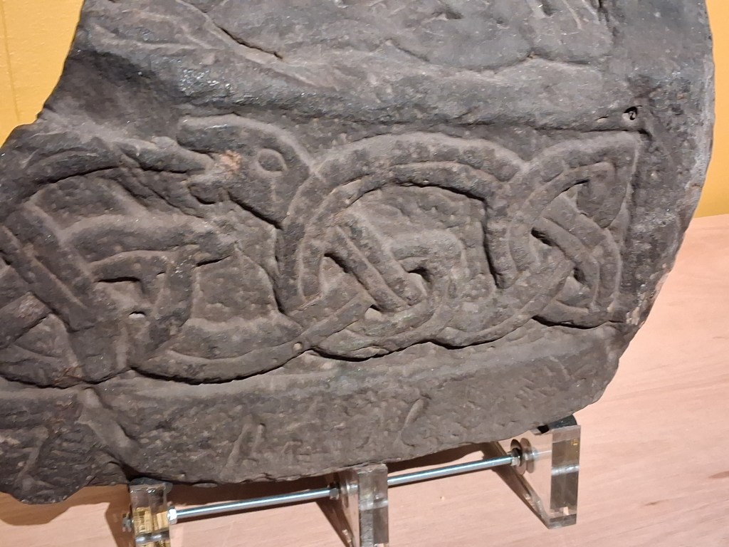
The Hogback from St. Alkmund’s church, now in Derby Museum. Image: Author
Putting all the evidence on one map, this is what we get:
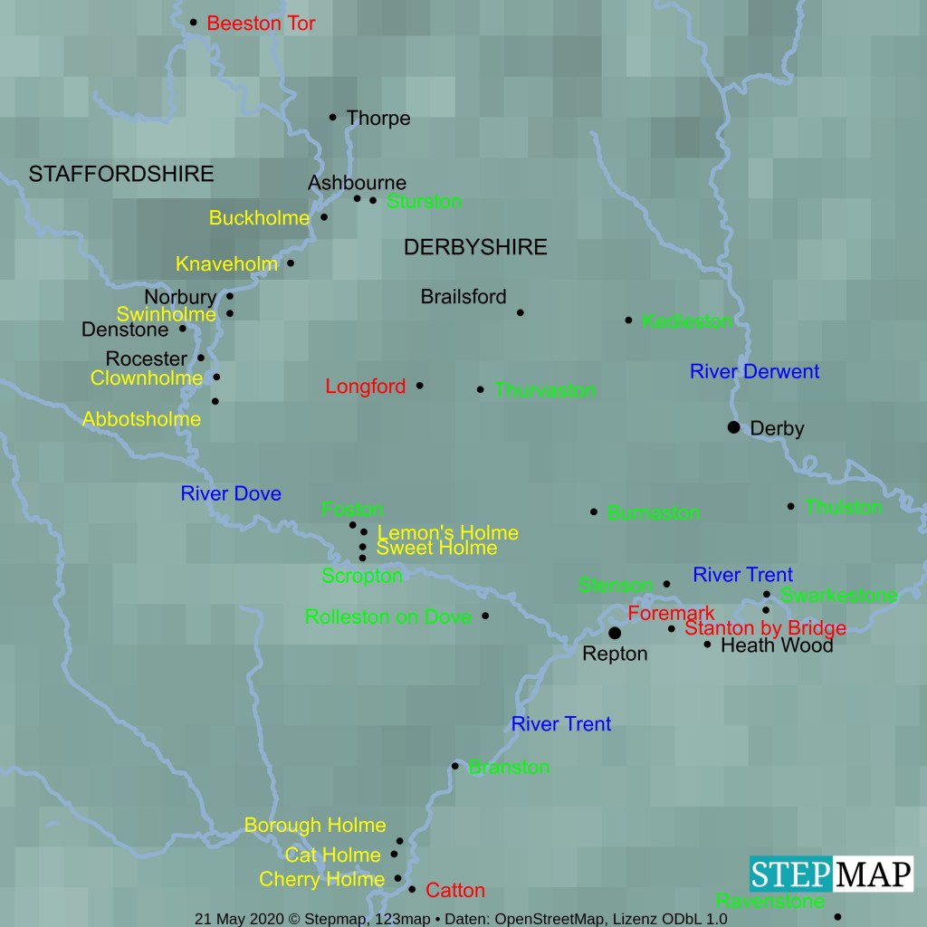
Key
- Yellow text, -holme names
- Green text, hybrid names
- Red text, find spots
- Blue text, rivers
- Black text, other sites mentioned in the article
Conclusions
At first glance there isn’t much evidence for a Viking presence in south Derbyshire beyond Repton and its immediate environs. However when minor place names and finds evidence are mapped it is clear that there was a significant Viking presence, mainly in the Trent and Dove Valleys, but there is also a limited presence across the region. There are also hints of a Viking presence in north Staffordshire and the attraction here may have been the deposits of mineral wealth. One interesting feature of the -holme place names in the Dove valley is that they are all on the Derbyshire side of the river and it is possible that the farms were planted there as a boundary marker, perhaps as some sort of pre-treaty landgrab by Vikings from Derby who marched along the roman road to Rocester and the Dove Valley. This map gives a clear indication that the extent of the Danelaw lay along the border between Derbyshire and Staffordshire.
References
Biddle M and Kjølbye-Biddle B (1985) The Repton Stone in Anglo-Saxon England Vol 14, 233-292 Cambridge University Press, Cambridge
Buteux S and Chapman H (2009) Where Rivers Meet, CBA Research Report 161, CBA
Ekwall E (1960) The Concise Oxford Dictionary of English Place-Names 4th Edition OUP, Oxford
Garmonsway G (Various editions) The Anglo-Saxon Chronicle, Everyman, Dent, London
Gregory R (2017) Holme from Home https://emidsvikings.ac.uk/items/holme-from-home-east-midland-place-names-and-the-story-of-viking-settlement/
Hadley D M and Richards J D (2018) In Search of the Viking Great Army: Beyond the Winter Camps, Medieval Settlement Research 33 1-17
Hawkes J and Sidebottom P (2018) Corpus of Anglo-Saxon Stone Sculpture Vol XIII Derbyshire and Staffordshire, Oxford University Press, Oxford
Jarman C (2019) Resolving Repton Current Archaeology 352 (July 2019) 18-25
Jesch J (2018) Some Derbyshire Warriors https://emidsvikings.ac.uk/blog/some-derbyshire-warriors/
Kay S (2010) Distrib ution of Scandinavian place names in England https://www.flickr.com/photos/stevefaeembra/4479234771/ Licensing: https://creativecommons.org/licenses/by-sa/2.0/
Portable Antiquities Scheme https://finds.org.uk
Richards J D (2004) Excavations at the Viking Barrow Cemetery at Heath Wood, Ingelby, Derbyshire The Antiquaries Journal 84 23-116
Wilson G (1926) Some Caves and Crags of Peakland, Wilfred Edmunds Limited, Chesterfield
