In the middle of the 9th century the area which is now Derbyshire was part of the Anglo-Saxon kingdom of Mercia. Britain had been subjected to sporadic Viking raids since the end of the 8th century but in 865 Viking tactics changed. A great army invaded and made their intentions clear; they wanted land on which to settle and farm. They overwintered at Repton in 873-874 and this led to the overthrow of the Mercian king and his replacement by Ceolwulf II. The Vikings returned to Mercia in 877 and negotiated the division of Mercia with land to the north and east of Watling Street (the old Roman road running from London to Wroxeter) being given to the Vikings and Ceolwulf retaining control of the rest of Mercia. In the last quarter of the 9th century the Vikings consolidated their hold on the north and east of the country and the area controlled by them is now known as the Danelaw. So, what was the extent of the Danelaw?
The Penguin Historical Atlas of the Vikings hedges its bets when describing the extent of the Danelaw. On page 79, when looking at place name evidence, the map shows the border of the Danelaw following the route agreed by Alfred and Guthrum, then continuing up Watling Street (the modern A5 follows the same route) and ending at the Welsh border. On page 68 the map shows the border of the Danelaw in 902. This starts off the same but somewhere near Tamworth the border leaves Watling Street and heads off northwards, follows the border between Derbyshire and Staffordshire and then the border between Lancashire and Cheshire before reaching the Mersey. Rebecca Gregory, in Viking Nottinghamshire, has a different view. In her map, Danelaw in the late 9th century, the Danelaw border, although it roughly follows Watling Street approximately, does not follow it exactly. Again it heads off northwards, through the middle of Derbyshire, through Lancashire and turns towards the Irish Sea along the River Ribble. Having said that the text in her book is slightly different; she has the boundary of the Danelaw stretching from London to the Mersey. Dawn Hadley in ‘The Northern Danelaw’ doesn’t have the Danelaw reaching the Irish Sea at all, but including Yorkshire but not Lancashire to the west or Durham to the North. In this article I intend to review the evidence for the extent of the Danelaw using mostly settlement patterns, place name evidence, administrative boundaries and historical sources but there may be some relevant evidence from finds. I shall be looking at a small section at a time and publishing on the website as I go along. The first instalment is the Danelaw in Derbyshire.
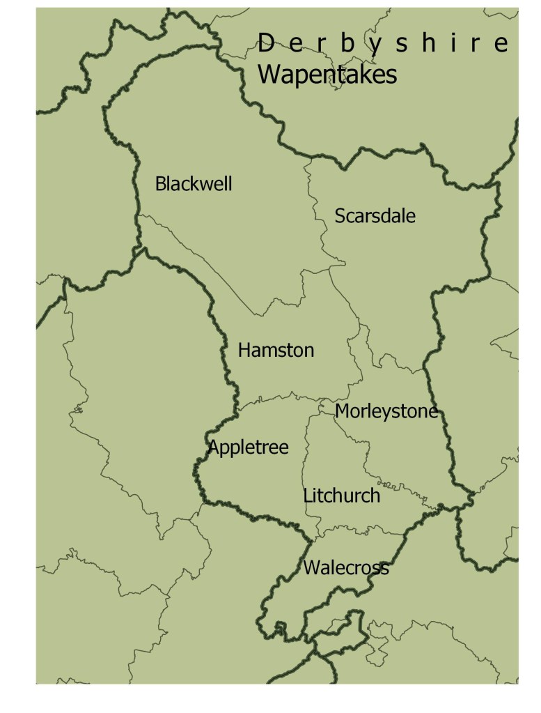
After the partition of Mercia it is likely that the East Midlands and Lincolnshire were settled firstly by the Great Army but then by other settlers from Scandinavia during this period. Although there was a forty year period of relative peace before Edward the Elder reconquered the five boroughs and received the submission of the King of York and other northern rulers, the Danelaw was not politically stable. In 939 Olaf Guthfrithsson took the Kingdom of York and the Five Boroughs, Edmund retook it for the Anglo Saxons in 944, Eric Bloodaxe took it in 948 but in 954 Eadred took it back for the Anglo-Saxons. At some stage in all that turmoil the shires of these disputed lands were created. In some cases the county boundaries appear to have followed the boundary of the Danelaw. For example the southwest border of Leicestershire follows Watling Street which is widely thought to have been the Danelaw border in this area. The shires were divided into hundreds or wapentakes, with the administrative areas in Anglo-Saxon areas known as hundreds and those in Viking areas known as wapentakes. These subdivisions of the counties may have been based upon earlier administrative areas. The map below shows the Derbyshire wapentakes at the time of the Domesday book. Although these were recorded about 100 years after they were formed it is reasonable to assume that they are a reasonable approximation of their original layout.
The strongest indicator of Viking presence in an area is place name evidence. Places ending in -by and -thorpe are believed to be strong indicators of a Scandinavian settlement and minor places containing holme, toft and kirk are also Scandinavian. The map below indicates the location of Scandinavian place names in Derbyshire and immediate surrounding areas. The three types of data come from different sources. The red dots are Scandinavian place names from the Gazetteer, yellow dots are minor Scandinavian names from Ordnance Survey Explorer 1:25,000 maps (mostly -holme names) and blue dots are hybrid place names mostly consisting of Scandinavian personal names followed by -ton. The hybrid names have been culled from an online talk by Rebecca Gregory and from The Place Names of Derbyshire (Cameron), Staffordshire Place Names (Poulton-Smith) and A Dictionary of Leicestershire and Rutland Place Names (Cox).

One feature of the map is the concentration of minor place names along the Derbyshire/Staffordshire border in south Derbyshire, and these have been discussed in the page ‘Vikings in South Derbyshire.’ There is a clear signal that the border of the Danelaw ran along the Dove Valley from its confluence with the River Trent in the south to the confluence of the Dove with the Henmore Brook near Ashbourne.
The most striking feature of the distribution map of Scandinavian place names is that there are no Scandinavian place names in the Blackwell wapentake and only three in the Hamston wapentake. Of those three, Starkholmes is included but it is not a typical holme name. Most holmes are found in flat bottomed river valleys where farmland has been created. Starkholmes is completely different as it is on a hillside so the name is a bit of an oddity. Kirk Ireton is included because it contains the Kirk element and the Ireton element may mean settlement of the Irish. The place name may indicate a settlement of the Hiberno-Norse and it is possible that this belongs to a different phase of settlement. The third Scandinavian place name in the Hamston Wapentake is Thorpe, on the Staffordshire border. Thorpe is close to the Scandinavian farmsteads of the Dove Valley but fairly isolated from other settlements, so again a bit of an oddity.
The Blackwell wapentake covers the area now known as the Dark Peak. Much of it is boggy moorland unsuitable for farming so hardly surprising that the Scandinavians chose not to settle there. The Hamston wapentake is mostly the area of the White Peak typified by the dry stone walls built from the carboniferous limestone of the area. This is also the lead mining district and we know the mines were producing lead in the Anglo-Saxon period. The farmland is suitable for grazing animals so there doesn’t seem to be a geographical reason why the Danes didn’t settle there. In a recently published book, Dr Phil Sidebottom identifies the area of the Blackwell and Hamston wapentakes as the land of the Pecsaetna and it is possible that this was an administrative district of Mercia when it was partitioned and this administrative district was not granted to the Vikings for settlement. Baker and Brookes also saw the area of the wapentakes of Blackwell and Hamston as originally not belonging to the Burghal territory of Derby. The shires were not created until the 10th century and although they were subdivided into hundreds or wapentakes there is some evidence that these were based upon earlier administrative divisions. My conclusion is that Mercia was partitioned according to Burghal territories and at that time the Blackwell and Hamston wapentakes were not part of the Derby Burghal territory so the border of the Danelaw is as shown on the map below. Blackwell and Hamston were added later, either before or during the creation of the shires.

There is other evidence to support the view that the Blackwell and Hamston wapentakes were not part of the Danelaw. Dawn Hadley states that ‘The charter issued by Athelastan to Uhtred concerning land at Ashford and Hope stated that Uhtred had purchased this land from the heathens for 20 pounds of gold and silver at the command of King Edward and Ealdorman Aethelred’. If Ashford and Hope had been within the Danelaw would Edward and Aethelred really have been able to force that transaction to take place? More likely that Ashford and Hope were outside the Danelaw and Edward and Aethelred were expelling Sandinavians who had encroached on Anglo-Saxon territory. This is confirmed by another transaction mentioned by Dawn Hadley. ‘At the same time Athelstan confirmed to one Ealdred land at Chalgrave and Tebworth (Beds) that he had purchased from the heathens for ten pounds.’ Chalgrave and Tebworth are on the Anglo-Saxon side of the border agreed by Alfred and Guthrum, so once again Anglo-Saxons are buying land from Scandinavians who have encroached on Anglo-Saxon territory. It seems there was a policy of enforcing agreed borders.
There is one place on the border of the Danelaw that needs some a bit more investigation, Ashbourne. Although the map isn’t clear, from Domesday, Ashbourne appears to be in the Hamston Wapentake. Modern Ashbourne straddles the Henmore Brook but all the ancient bits (church, market place, hall) are north of the river. The area to the south of the river is known as Compton but this is not mentioned in Domesday. In a later hundredal organisation Clifton and Compton form a detached parish in Morleystone and Litchurch hundred so there is something odd about the parish and administrative boundaries. Perhaps Ashbourne was a frontier town when the Danelaw boundaries were agreed, Ashbourne remaining in Mercian hands but Compton, just across the river was within the Danelaw. Both Compton and Ashbourne have a few street or field names with Scandinavian elements but there is no convincing evidence of a border.
The next instalment of mapping the extent of the Danelaw is The Danelaw in Leicestershire.
References Mentioned in the Text
Baker J. and Brookes S., Governance at the Anglo-Scandinavian Interface: Hundredal Organization in the Southern Danelaw. Journal of the North Atlantic, Special Volume 5: 76-95
Cameron K., The Place-Names of Derbyshire Vols I, II and III, Cambridge University Press, 1959
Cox B., A Dictionary of Leicestershire and Rutland Place Names, EPNS 2005
Gazetteer of British Place Names, http://www.gazetteer.org.uk/purchase Last accessed 30/09/2020
Gregory R., Viking Nottinghamshire, Five Leaves Publications, 2017
Gregory R., Holme from Home, https://emidsvikings.ac.uk/items/holme-from-home-east-midland-place-names-and-the-story-of-viking-settlement/ Last accessed 30/09/2020
Hadley D., The Northern Danelaw, Continuum, 2001
Haywood J., The Penguin Historical Atlas of the Vikings, Penguin Books 1995
Poulton-Smith A., Staffordshire Place Names, Countryside Books 1995
Shapefile for County and Hundred boundaries, Archaeological Data
Shapefile for Roman Roads: https://darmc.harvard.edu/data-availability
Sidebottom P., Pecsaetna, OXBOW Books, 2020
