The evidence so far indicates that the border of the Danelaw ran down the middle of Derbyshire following hundredal or wapentake boundaries in the north of the county, then following the Dove Valley southwards until it joins the Trent. The border then runs south-west but it is not clear whether the border is following Icknield Street or the River Trent as they run parallel for about 10 miles. From the south of Derbyshire the Danelaw border ran down to Watling Street but the route it took is not immediately clear. The county boundary in south Derbyshire is quite complex and until the Victorian reforms of the county boundaries, Derbyshire had an exclave that was completely separated from the rest of Derbyshire. The complexity of the administrative boundaries in the area has recently been explored by Corcoran in the Derbyshire Archaeological Journal. He sees No Man’s Heath as a meeting place of several different hundreds.
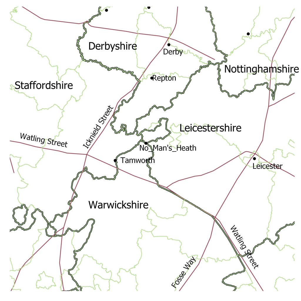
Key
Dark green borders – County boundaries at the time of Domesday (ADS) Light green borders – Hundred/Wapentake boundaries at Domesday (ADS) Red lines – Roman roads. Black dots – places mentioned in the text
The next map has scandinavian place names added for Derbyshire, Leicestershire, Warwickshire and Staffordshire.
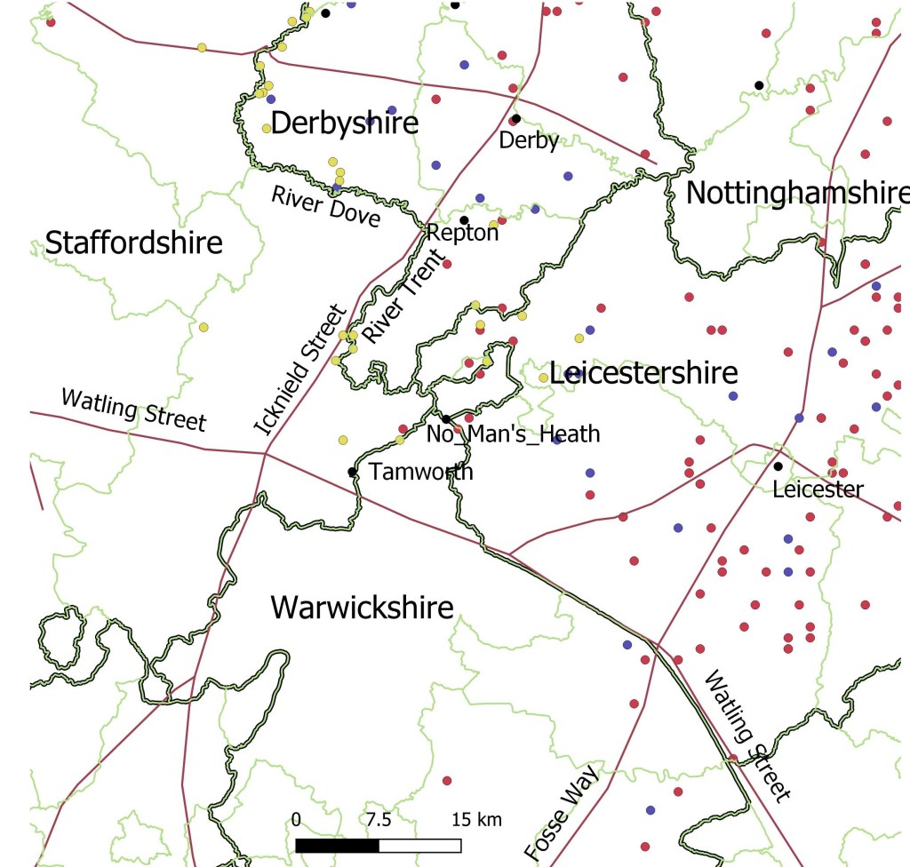
Red dots – place names from the gazetteer containing -by, thorpe, kirk, toft
Blue dots – hybrid place names mostly Scandinavian personal name + ton
Yellow dots – manually added minor place names with Scandinavian elements (mostly holme names)
The farms with -holme names in the Dove valley seem to be marking the extent of the territory of the Vikings of Derby (see this site, Vikings in South Derbyshire) but there are also -holme names in the Trent valley. Whilst the -holme names of the Dove valley are mostly on the eastern side of the Dove (within the Danelaw) in the Trent valley the -holme names are on the western side of the Trent. It is possible that here the Danelaw border is not delineated by the River Trent but by Icknield Street (this road is sometimes called Ryknield Street but there is another roman road with this name). It is not clear how far south this border goes (whether it is the Trent or Icknield Street). It doesn’t seem to go from here right down to Watling Street because the area around Tamworth is almost free of Scandinavian influence, apart from three minor placenames just to the north, Thorpe Constantine, Holmcroft and Thorpegorse cottages. These minor place names are close to Tamworth but the Anglo-Saxon chronicle implies that Tamworth was not within the Danelaw. According to the C version of the chronicle:
913 In this year, by the grace of god, Aethelflaed, the ‘Lady of the Mercians,’ went with all the Mercians to Tamworth and built the fortress there early in the summer, and afterwards that at Stafford before Lammas.
At this stage Aethelflaed appears to be reinforcing her borders before taking on the Danes of the Danelaw. There is no indication that she had to fight to gain control of Tamworth, she simply built a fortress there. In subsequent years she reinforces her border in the northwest and launches an attack on the Welsh. With those areas subdued she then attacks the Five Boroughs in 917 and captures Derby.
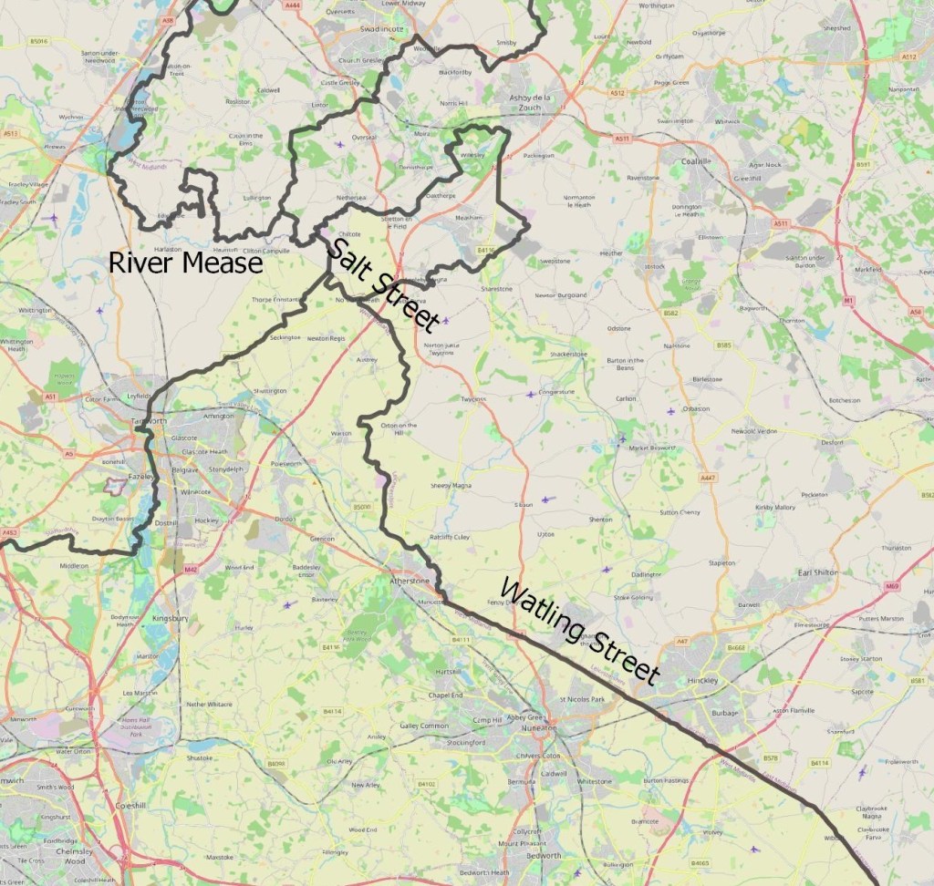
When Mercia was partitioned in 877 it looks as if the Mercians had some cards to play. After having Repton occupied by the Vikings they were desperate to keep hold of Tamworth and surrounding countryside (including the royal estate of Seckington) and maintain some distance between Tamworth and the Danelaw border. The three minor names already mentioned would either be a product of later encroachment by the Danes or later naming. If Tamworth wasn’t in the Danelaw the Danelaw border must have cut across from south Derbyshire to Watling Street. Most commentators have the Danelaw border following the old county boundaries of Derbyshire and Leicestershire (eg Hadley in The Northern Danelaw). Of course the county boundaries came after the Danelaw boundary but may have reused the existing Danelaw boundary. This is certainly possible but this does leave a large area of Leicestershire just north of Watling Street with no Scandinavian place names. My conclusion is that the Danelaw border ran from the River Trent, up the River Mease to Clifton Campville. From there it followed Salt Street down to No Man’s Heath then continued in a straight line down to the junction of Watling Street with the Fosse Way. Salt Street is an ancient track that continues southeast after No Man’s Heath along a low ridge but then disappears in the lower lying land. The current county boundary follows part of that route. (If you drive up the M42 there is a bridge that carries Salt Street over it and that bridge is the county border between Warwickshire and Leicestershire).
This is the same map with Danelaw boundary added:
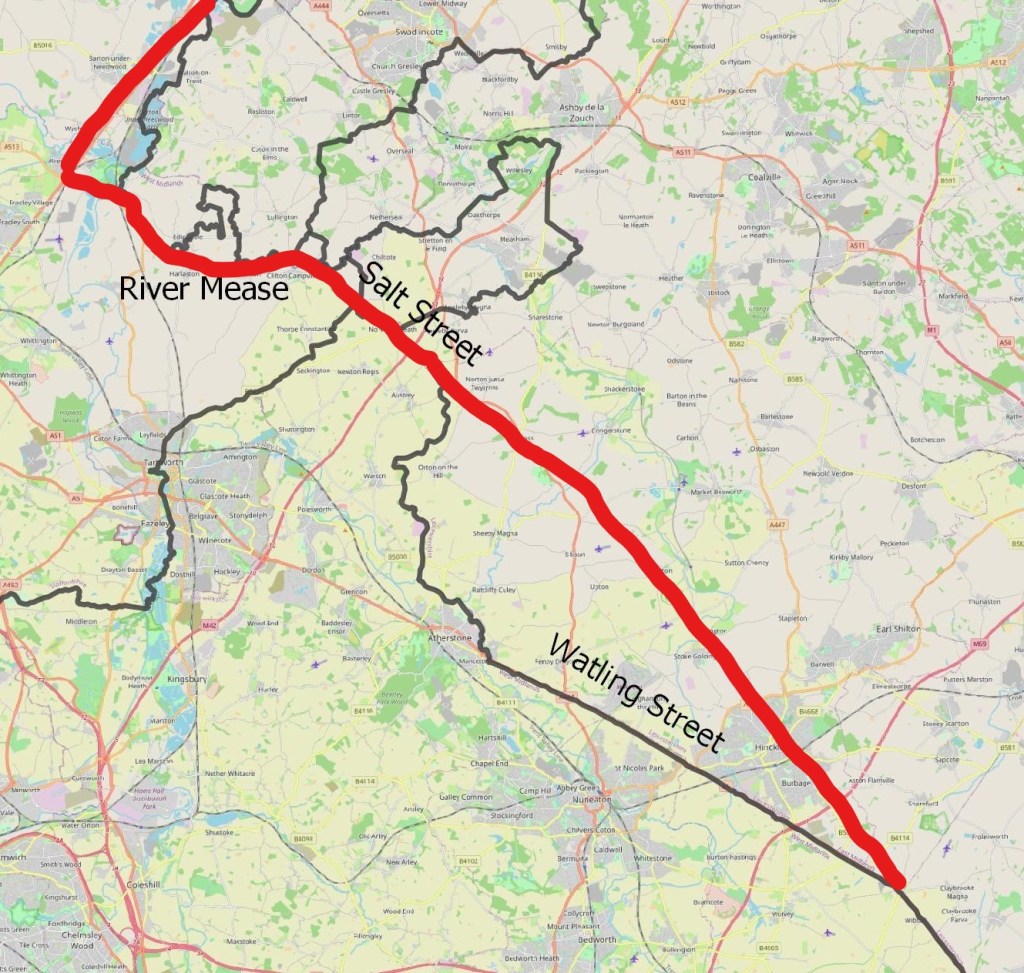
This map shows the Danelaw boundary (Red line) in relation to county boundaries at the time of Domesday book. The triangle bounded by the Danelaw border, Watling Street and the M42 is completely devoid of scandinavian place names, suggesting that Watling Street wasn’t the Danelaw border in this section.
References
Corcoran A. The Origins of South Derbyshire, Derbyshire Archaeological Journal, 2019, Volume139:53-84
Hadley D., The Northern Danelaw, Continuum, 2001
Shapefile for County and Hundred boundaries, Archaeological Data
Shapefile for Roman Roads: https://darmc.harvard.edu/data-availability
