
Ringsbury Camp is an Iron Age hillfort near Purton in Wiltshire. As far as I am aware it has never been excavated or surveyed, so we know very little about it. However, it is well preserved, and features not visible to the naked eye are visible on LIDAR images. It sits on a bed of Corallian limestone and this can be seen at the entrance in the south eastern corner of the hillfort.
The hillfort (red dot on the map) is easily accessed by a short walk from Purton. There is a footpath that skirts the southern perimeter of the hillfort, but there is no public access to the rest of the monument.

© Ordnance Survey
Hillforts come in all shapes and sizes and it is unlikely that all hillforts had the same function. One proposed function of hillforts is that they were concerned with the management of animals. Most hillforts were built in the period 800 – 400 BC and this period coincided with a climatic downturn with prolonged periods of colder and wetter weather, and hillforts could have been built to protect sheep from winter storms (see Climate Change and the Iron Age on this website, https://before1066.com/climate-change-and-the-iron-age/). There is evidence from the LIDAR image that Ringsbury Camp had other roles to play in the management of sheep.

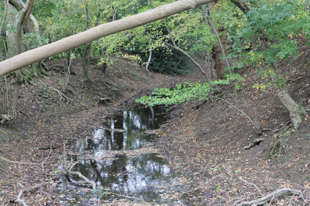
To the north of the hillfort are two annexes; annexes are a common feature of Iron Age hillforts and are generally believed to be connected with stock management. There is access to each annex from the hillfort ditch via a gap in the outer bank. At these points of access, the ditch is frequently waterlogged.
Also on the LIDAR image near the north west entrance is an additional bank and ditch that extends from the western entrance to the first annex.
On the south side of the hillfort the public footpath runs along the top of the outer bank and has worn a groove in the bank.
Where the Mud Lane footpath joins the fort there is an accumulation of loose stone.
My (very rough) diagram shows the features a little more clearly.

My hypothesis is that sheep approached the hillfort from the east along Mud Lane. Where Mud Lane joins the hillfort the accumulation of loose stone indicates that the bank of the hillfort may have been faced with stone and this has collapsed thanks to the action of tree roots. The sheep went up the incline to the top of the outer bank and followed the footpath around to the western entrance. The action of the sheep has worn a groove in the top of the bank.
When the sheep got to the western entrance the sheep were sorted. Some went into the waterlogged section of ditch which could have been a sheep-wash. Some went through the sheep-wash and exited into the first annex and some exited into the second annex. There is also a route around to the first annex that avoids the sheep-wash. So why were they being sorted? There several possibilities:
- Sorting the sick from the healthy
- Sorting pregnant from the non-pregnant
- Sorting by owner; if the sheep were marked in some way the flock could have sheep from several owners
- Sorting by the quality of the wool; castrated rams produced the best wool
I am sure there are other reasons why the sheep would have been inspected and sorted, but it does seem that the sorting process is a good explanation for the observed landscape features.
A different LIDAR image , supplied by Phil Barrett, shoes some additional features not evident in the image above.
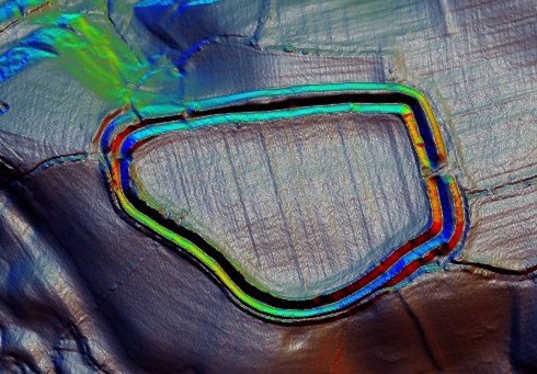
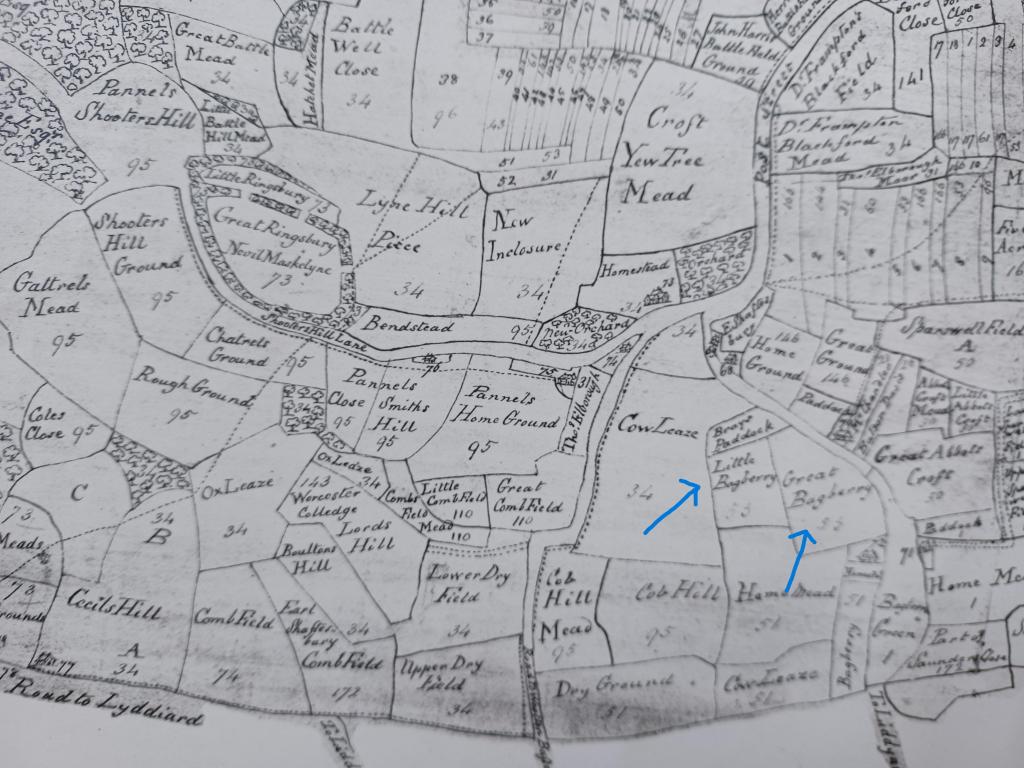
The larger, second annex appears to have a route around the hillfort to the eastern entrance. So, animals sorted into this annex could return safely to the interior of the fort. The theory that the enclosures on the north side are indeed annexes is confirmed by the 1744 Enclosure Map of Purton (a copy of which can be seen in Purton Museum).
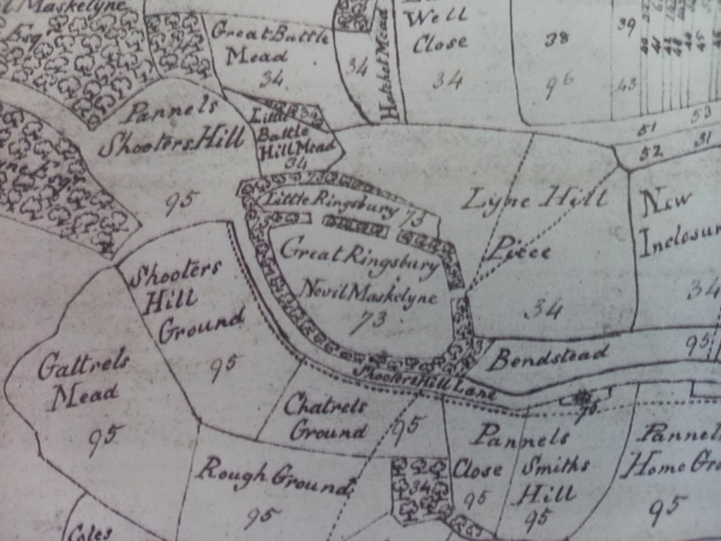
This map clearly shows Great Ringsbury and Little Ringsbury with two entrances between them, so confirming the structure proposed from the LIDAR images.
There is other evidence that Ringsbury Camp is concerned with the management of sheep. The sheep probably spent time away from the hillfort and were brought to it for the processes described above. One possible location would be Purton Common. The road leading from Purton Common towards Ringsbury Camp is known as Hogg’s Lane. Today a hog is usually a word used for a pig but it is also a word for a one-year old sheep, Hogg’s Lane could be the route taken when the young sheep were being moved to the hillfort.
For more about climate change and the Iron Age go to https://before1066.com/climate-change-and-the-iron-age/ . This was my dissertation for the MSc in Applied Landscape Archaeology at Oxford Continuing Education Department.
I have recently (Nov 2023) identified additional features outside the hillfort although these marks could be made by circular cattle feeders that were moved about the fields.

To the north of the annex there are several circles clearly visible in green against a parched background, indicating the presence of the ditches which are a feature of Iron Age huts. The rest of the field and an adjacent field also show the possible presence of features but they aren’t quite as clear cut.
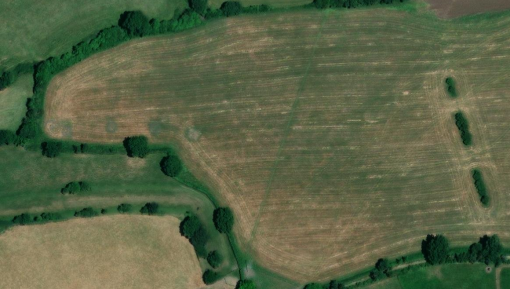
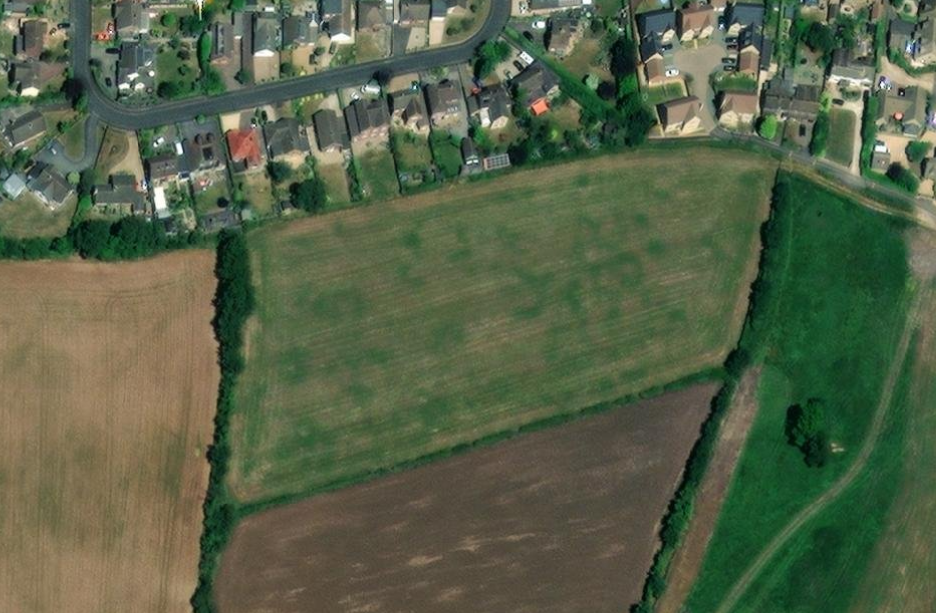
However these crop marks can also be created by agricultural activity and circular animal feeders could produce similar markings in aerial photographs. The site seems worthy of a geophysical survey.
Is there another one just like the other one?
Less than 1km to the west of Ringsbury Camp is Bagbury Farm , adjacent to Bagbury Lane. There is some evidence that another hillfort may be hiding in this area. The obvious clue is in the name; the suffix -bury means fortified place and is shared by many hillforts. The next clue comes from the route taken by Bagbury Lane. The lane curves around before shooting off at a right angle. It could be curving around the remains of a hillfort that are no longer visible. The third clue comes from the 1744 enclosure map of Purton. As seen above the map shows Ringsbury Camp complete with its annexes and is divided into Great Ringsbury and Little Ringsbury. On the 1744 map there are also two adjacent fields known as Great Bagbury and Little Bagbury, so this could indicate that there was once a hillfort with annexes in this area. And finally there is LIDAR and aerial photography which appears to show a curved ditch along what would be the southern edge of a hillfort slightly larger than Ringsbury Camp.
Relationship between Ringsbury Camp and Bagbury

©Ordnance survey
Image showing crop mark, indicating ditch
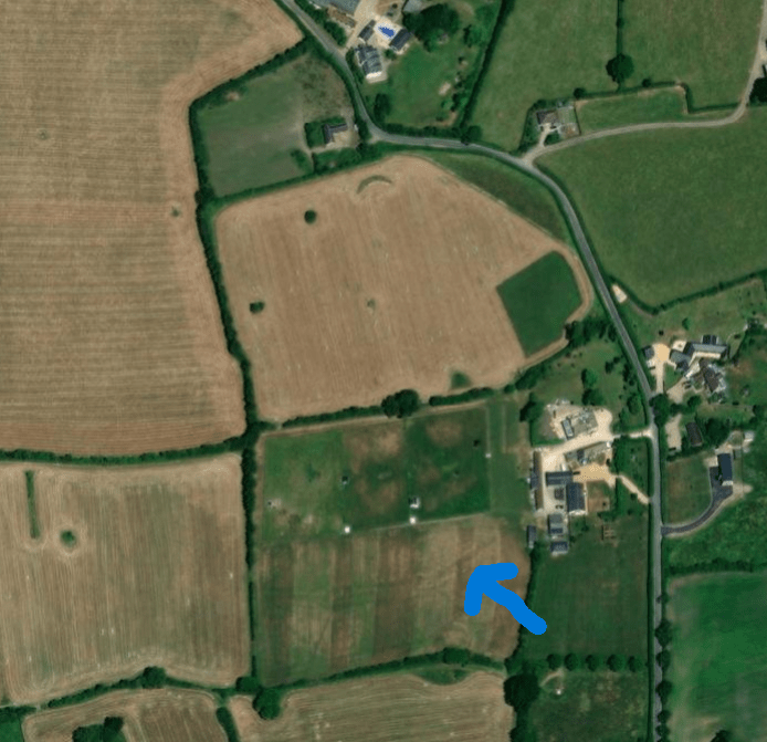
LIDAR image showing the same ditch and additional ditch

1744 Map showing Great Bagberry (sic) and Little Bagberry (sic)
There is enough evidence to suggest that there is a hillfort on the west side of Bagbury Lane.
Acknowledgements:
The first LIDAR image was created by downloading data from the DEFRA site and uploading to ArcGIS The second LIDAR image was supplied by Phil Barrett
The photograph of the waterlogged ditch is my own.
The aerial photographs came from ARCHI UK https://www.archiuk.com/
A copy of The 1744 Purton Enclosure Map is on display in Purton Museum but if you need more information on this map you may contact me using the website contact details
