Lutudarum is a Roman place name listed in the Ravenna Cosmography. It is in a group of places in Cheshire and Derbyshire and is listed next to Derventio, believed to be the Roman fort of Little Chester, just north of Derby City Centre.
The Romans mined lead in Derbyshire and cast smelted lead into blocks known as pigs. These pigs of lead are known to be Roman because of the inscriptions in Latin. The inscriptions often include (in abbreviated form) the name of the emperor at the time of casting or the name of individuals trading the lead, and sometimes the abbreviation LVT. It is a reasonable assumption the LVT refers to Lutudarum and that this was a settlement or fort connected with lead mining. The location of Lutudarum has been the subject of much speculation and Chesterfield, Crich, Matlock, Cromford, Wirksworth and Carsington have all been proposed as possible locations. Harry Lane in his book ‘The Romans in Derbyshire’ reviewed the evidence for the various locations and also considered several known Romano British settlements. There is so much speculation because there is no evidence. Wirksworth was favoured by many as a possible location because of its later role as an administrative centre for lead mining but there is absolutely no evidence of a Roman settlement in Wirksworth.
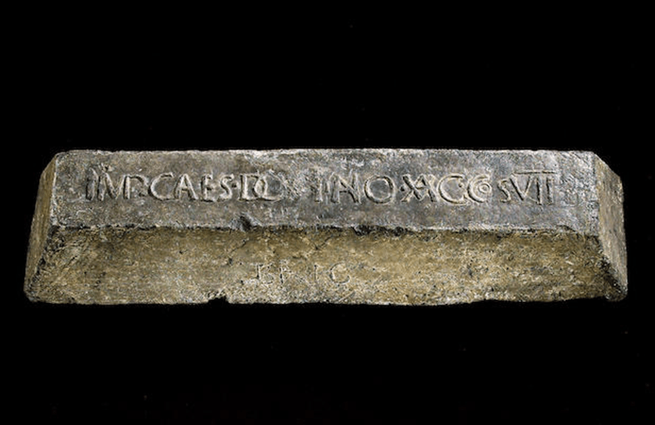
Fig. 1 Roman Pig of Lead from Yorkshire
My objective in this blog is to map the distribution of the pigs of lead that can be attributed to a Derbyshire origin to see what we can deduce about the source and distribution of the lead. Pigs of lead from Derbyshire have been found as far north as the Humber estuary and as far south as Sussex.

Fig.2 The distribution of Derbyshire pigs of lead in Britain
There is an obvious concentration of pigs of lead in central Derbyshire

Fig.3 Roman Pigs of Lead in Derbyshire
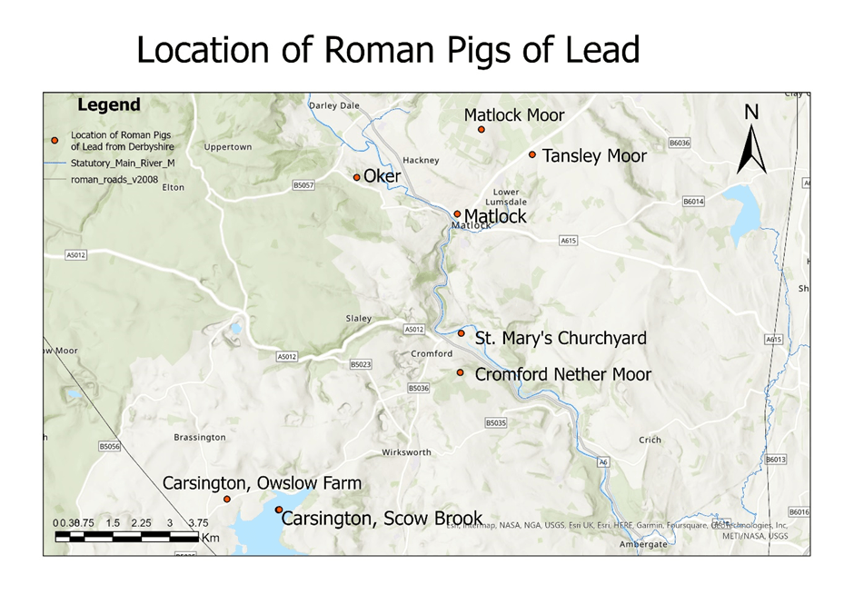
Fig.4 Roman pigs of lead in Matlock/Cromford/Wirksworth area
The largest concentration of pigs of lead is in the Matlock/Cromford/Wirksworth area and there is a group of six pigs of lead that are not close to a known Roman road. Most of the other known pigs of lead are within a few miles of a known Roman road.
From the distribution of the pigs of lead it looks as if there several sources of lead and several smelting sites within a fairly small area. If there was one smelting site you would expect the pigs of lead to be concentrated in a particular area or along a particular route. So, if there were several extraction sites and several smelting sites. Lutudarum was not necessarily directly involved in the process. It may have just been an administrative site for this area.
Since all six of this group are not near known Roman roads but are close to the River Derwent this is the most likely route for transport out of the area. In his book, Lane argues that the Derwent was probably navigable by shallow-draughted boats in the Roman period. It looks as if some pigs of lead were transported all the way down the Derwent then down the Trent to Petuaria (Brough on Humber). Three of the pigs of lead from this area (Broomfleet, South Cave and Ellerker) were found in parishes along the north bank of the Humber Estuary between the outflow of the Trent and Petuaria suggesting that this was the route. Some have suggested that these pigs of lead were destined for export but it is more likely that they were heading for York which was being rebuilt in stone at the end of the first century and the start of the second century. The lead had been floated downstream via the Derwent and Trent but was too heavy to be transported upstream via the Ouse so was transferred to the Roman road from Petuaria to York. Other pigs of lead appear to have been distributed via the Roman road network and may have joined the road network at Derventio (Little Chester, Derby).
There have been several archaeological digs at Little Chester (Derventio) by York Archaeology. The most recent finished in August 2025 and raised questions about the status of the Roman occupation of the site. Although the excavated remains clearly show the classic playing card shape of a Roman fort there is very little archaeological evidence for a military presence and the archaeologists prefer to use the term “defended settlement” when talking about the site. The defences are quite close to the River Derwent so if Derventio had a role in controlling river traffic you would expect a harbour or wharves or maybe just a beach, but no evidence of this has yet been found. The only hint that this “harbour area” did have an important role is a defensive ditch on the north side. It is possible that Derventio was a distribution centre for Derbyshire lead, with lead being off-loaded from small vessels onto larger vessels for its journey downstream along the Trent, or the Roman roads running north and south along Ryknield Street and west along Long Lane.
What does this tell us about the location of Lutudarum?
If the majority of the lead mined in the late 1st or early 2nd century was coming from the Matlock/Cromford/Wirksworth area and was being transported out of the area down the Derwent, it would make no sense to have the administrative centre in Chesterfield or Crich. My guess (and it is only a guess) is that Lutudarum would be sited at a strategic location where the Romans could monitor lead production (eg making sure that the locals aren’t smelting their own lead for the black market) and also monitor the transport of lead out of the area. The best place to perform this latter task would be at Cromford; all the lead would come downstream to here and lead from Cromford Nether Moor would join the Derwent here.
There are two interesting sites in Cromford. Firstly there is the flat area of ground just below the Cromford Mills Car Park. Part of this area was where the Arkwright family built their family chapel, now St Mary’s church, and the other part is Smelting Mill Green, known to have a lead smelter here in 1575. This area would be large enough to accommodate a small Roman fort and is ideally placed to monitor traffic on the Derwent.

Fig.5 St. Mary’s Church, Cromford

Fig.6 Information Board for Smelting Mill Green
The 1899 large scale Ordnance Survey map of the area shows a v-shaped cutting that gave access from the area to the River Derwent but without archaeological investigation it is impossible to date the feature. However it does suggest that the river could have been used as a means of transport out of the area.

Fig.7 1899 Ordnance Survey map of Smelting Mill Green
The other site of interest in Cromford is St. Mark’s churchyard. The church itself has been demolished but the graveyard is still in use. This church preceded St. Mary’s as the parish church and some locals think that the pigs of lead found near St. Mary’s may actually have been found at St. Mark’s. The interesting thing about the churchyard is that it is an almost perfect rectangle about 100m by 60m. Almost Roman fort shaped!
Unfortunately there is very little archaeological evidence that supports any particular location. There is a scattering of Roman finds from the Matlock/Cromford/Wirksworth area but nothing that would suggest a Roman settlement.
What about Carsington?
The Roman Roads map was published in 2008 and is now out of date. On the map the road from Buxton to Little Chester was conjectural after Longcliffe, but Dave Ratledge’s LIDAR analysis has shown that the road runs very close to the Scow Brook site (now under Carsington Reservoir). The problem I have with Carsington is the dating evidence. The pigs of lead that mention LUT (Lutudarum) are late 1st or early 2nd century but the Scow Brook site seems to be later than this. It has been badly damaged by ploughing and was difficult to date and there was very limited evidence for occupation before 150. The pigs of lead from this area are 3rd or 4th century from their context. There could be other sites in the vicinity that did exist in the early part of the occupation of Derbyshire but there is no reason to favour Carsington over other sites.
Other Romano-British sites in the area eg Rainster Rocks are also from a later phase of lead extraction.
In summary there is no archaeological evidence for a Roman settlement in the Matlock/Cromford/Wirksworth area of Derbyshire from the early part of the conquest. My favoured location for the site of Lutudarum is Cromford but we need some archaeology. I think I shall try Time Team!
References
Lane, H. (1986) The Romans in Derbyshire, Lead Mining and the Search for Lutudarum. Veritas Publications (Derbyshire), Bolsover
Ratledge, D. (2021) Derbyshire Archaeological Journal 141 7-31
